Kenya’s heavy rainfall advisory stays in effect until March 9 at 7pm, with the Kenya Meteorological Department warning that the wet spell keeps pounding hard right now. The peak period rolls on through the weekend, bringing moderate to heavy downpours that could dump 40 mm to 100 mm in isolated spots across many areas.
The advisory, first put out on March 3, covers almost the whole country except Lamu and parts of Wajir. It kicked in on the evening of March 3 and runs straight through to Monday evening. Right now, on March 7, the rains hit strongest in places like the Lake Victoria Basin; western Kenya; bits of the Central Highlands, including Nairobi; southeastern lowlands; and the coast. Thunderstorms pop up often, making roads slippery and rivers swell fast.
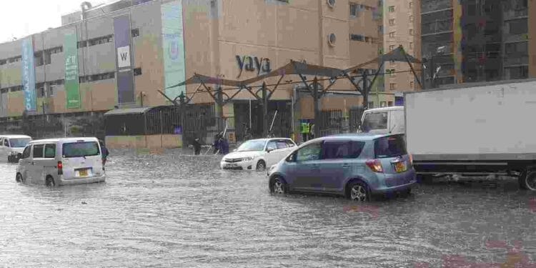
In Nairobi and the surrounding metro area, expect widespread showers today and tomorrow. Some neighbourhoods might see 20mm to 60mm easily, with heavier pockets up to 80mm or even 100 mm in low-lying spots like Kibra, Dagoretti, Embakasi, Makadara, Kamukunji, Roysambu, Westlands, Langata, and Mathare.
Soils already sit soaked from earlier rains, so even a short burst can spark flash floods or runoff that turns streets into rivers. Kiambu County faces similar trouble, especially around Gatundu, Thika, Ruiru, Limuru, Kikuyu, and Githunguri. Kajiado and Machakos also get tagged for scattering heavy falls, with orange and red zones signalling big risks near the Nairobi border.
The department points out that this wet stretch ties into the long rainy season that usually starts around March. They’ve seen above-average falls in many spots already, and the pattern holds strong through the advisory period.
Peak intensity hits between March 4 and 7, which lines up with what’s happening today. After that, things ease a bit in most places by March 8, though heavy stuff lingers longer in the western and lake regions right up to the 9th.
People feel the impact every day. Flooding pops up in urban low spots, landslides threaten hilly areas, and water gets dirty from runoff, raising chances of sickness if folks drink untreated sources.
Roads turn treacherous with poor visibility during storms, and drivers slow down or get stuck. In rural parts, farms take hits from waterlogging, while rivers like those in the Rift Valley and Lake Basin rise quickly. Authorities monitor dams and bridges for potential overflow.
KMD urges everyone to stay alert. Avoid crossing swollen streams on foot or by vehicle. Don’t camp near riverbanks. Clear drains around homes to let water flow away. If lightning cracks, get indoors and stay away from open fields, tall trees, or metal objects. Check updates from the department’s site or social pages for short-term changes.
The weekend looks soaked, with isolated storms likely to keep things lively. Some areas might dry out a touch early next week, but the advisory stresses that risks stick around until the full expiry on Monday evening. Nairobi folks, especially, should prep for more afternoon and evening showers that could snarl traffic or flood basements.
This kind of weather tests how ready communities stay for the rainy months ahead. Markets slow when goods can’t move easily, schools send kids home early in severe spells, and emergency teams stand by for calls about stranded people or collapsed structures. Yet many Kenyans push through, carrying on with daily routines under umbrellas or raincoats.
As the advisory counts down its final days, the message stays simple: watch the skies, mind the water, and take no chances. The peak might pass soon, but these rains remind everyone how quickly calm turns to chaos when the clouds open up. Stay dry out there, and keep tuned for the next update from the Met experts.